List of All Stations
Dickson Creek
Dickson Lake Station
Fraser River at Mission 08MH024
Leqamel Deroche Creek
Leqamel Dewdney Bridge
Leqamel Nicomen Bridge
Leqamel Weather Station
Lower Norrish Creek
Norrish Creek
Taylor Rd Dyke Culvert
Low
1 Station
  • Taylor Rd Dyke Culvert
Medium
0 Stations
High
0 Stations
ECCC Weather Alerts
Orange warning - Rainfall - In effect
Severity Severe
Urgency Immediate
Event rainfall
Certainty Likely
Effective Mar 20, 2:28 PM PDT
Expires Mar 20, 7:02 PM PDT
Show details
A long episode of rain, at times heavy, continues.

Prolonged Atmospheric River Event

Where: Fraser Valley Central and East - including Hope

What and when:
- Total rainfall amounts from Wednesday to today: 100 to 120 mm with higher amounts possible near the mountains

Impacts:
-Prolonged heavy rain on snow combined with mountain snow melt could lead to very enhanced responses in river systems and potential for flooding.
-Extensive water pooling on roads and washouts may occur.
-Enhanced risk of landslides due to saturation of landscapes.

Remarks:
An atmospheric river will remain over the South Coast of B.C. through this afternoon bringing periods of heavy rain across the Fraser Valley. With freezing levels near 2000 to 2500 metres, snowmelt from higher elevations may increase the impacts associated with this rainfall event.

Periods of heavy rain will begin to taper off late this afternoon as a cold front sweeps across the Lower Mainland. Strong southwesterly winds will develop in the wake of the front this afternoon. Freezing levels will also lower to 500 to 1000 metres by Saturday.

###

Localized flooding is likely. Some roads may become impassable. Travel delays and/or cancellations are likely. Damage to some critical infrastructure is possible. Landslides may occur in vulnerable areas such as steep slopes, deforested areas or recent burn scars.

Rainfall warnings are issued when significant impacts are expected due to rainfall amounts.

Please continue to monitor alerts and forecasts issued by Environment Canada. To report severe weather, send an email to BCstorm@ec.gc.ca or post reports on X using #BCStorm.
Orange warning - Rainfall - Ended
Severity Minor
Urgency Past
Event rainfall
Certainty Observed
Effective Mar 20, 2:28 PM PDT
Expires Mar 20, 3:28 PM PDT
Show details
###
Orange warning - Rainfall - In effect
Severity Severe
Urgency Immediate
Event rainfall
Certainty Likely
Effective Mar 20, 12:35 PM PDT
Expires Mar 20, 7:01 PM PDT
Show details
A long episode of rain, at times heavy, continues.

Prolonged Atmospheric River Event

Where: Fraser Valley Central and East - including Chilliwack and Hope

What and when:
- Total rainfall amounts from Wednesday to today: 100 to 120 mm with higher amounts possible near the mountains

Impacts:
-Prolonged heavy rain on snow combined with mountain snow melt could lead to very enhanced responses in river systems and potential for flooding.
-Extensive water pooling on roads and washouts may occur.
-Enhanced risk of landslides due to saturation of landscapes.

Remarks:
An atmospheric river will remain over the South Coast of B.C. through this afternoon bringing periods of heavy rain across the Fraser Valley. With freezing levels near 2000 to 2500 metres, snowmelt from higher elevations may increase the impacts associated with this rainfall event.

Periods of heavy rain will begin to taper off this afternoon as a cold front sweeps across the Lower Mainland. Strong southwesterly winds will develop in the wake of the front this afternoon. Freezing levels will also lower to 500 to 1000 metres by Saturday.

###

Localized flooding is likely. Some roads may become impassable. Travel delays and/or cancellations are likely. Damage to some critical infrastructure is possible. Landslides may occur in vulnerable areas such as steep slopes, deforested areas or recent burn scars.

Rainfall warnings are issued when significant impacts are expected due to rainfall amounts.

Please continue to monitor alerts and forecasts issued by Environment Canada. To report severe weather, send an email to BCstorm@ec.gc.ca or post reports on X using #BCStorm.
Orange warning - Rainfall - Ended
Severity Minor
Urgency Past
Event rainfall
Certainty Observed
Effective Mar 20, 12:35 PM PDT
Expires Mar 20, 1:35 PM PDT
Show details
###
Orange warning - Rainfall - In effect
Severity Severe
Urgency Immediate
Event rainfall
Certainty Likely
Effective Mar 20, 4:18 AM PDT
Expires Mar 20, 6:59 PM PDT
Show details
A long episode of rain, at times heavy, continues.

Prolonged Atmospheric River Event

Where: Fraser Valley

What and when:
- Total rainfall amounts from now to Friday: 100 to 120 mm with higher amounts possible near the mountains

Impacts:
-Prolonged heavy rain on snow combined with mountain snow melt could lead to very enhanced responses in river systems and potential for flooding.
-Extensive water pooling on roads and washouts may occur.
-Enhanced risk of landslides due to saturation of landscapes.

Remarks:
An atmospheric river will remain over the South Coast of B.C. through this afternoon bringing periods of heavy rain across the Fraser Valley. With freezing levels near 2000 to 2500 metres, snowmelt from higher elevations may increase the impacts associated with this rainfall event.

Periods of heavy rain will begin to taper off this afternoon as a cold front sweeps across the Lower Mainland. Strong southwesterly winds will develop in the wake of the front this afternoon. Freezing levels will also lower to 500 to 1000 metres by Saturday.

###

Localized flooding is likely. Some roads may become impassable. Travel delays and/or cancellations are likely. Damage to some critical infrastructure is possible. Landslides may occur in vulnerable areas such as steep slopes, deforested areas or recent burn scars.

Rainfall warnings are issued when significant impacts are expected due to rainfall amounts.

Please continue to monitor alerts and forecasts issued by Environment Canada. To report severe weather, send an email to BCstorm@ec.gc.ca or post reports on X using #BCStorm.
Orange warning - Rainfall - In effect
Severity Severe
Urgency Immediate
Event rainfall
Certainty Likely
Effective Mar 20, 4:18 AM PDT
Expires Mar 20, 6:59 PM PDT
Show details
A long episode of rain, at times heavy, continues.

###

Localized flooding is likely. Some roads may become impassable. Travel delays and/or cancellations are likely. Damage to some critical infrastructure is possible. Landslides may occur in vulnerable areas such as steep slopes, deforested areas or recent burn scars.

Rainfall warnings are issued when significant impacts are expected due to rainfall amounts.

Please continue to monitor alerts and forecasts issued by Environment Canada. To report severe weather, send an email to BCstorm@ec.gc.ca or post reports on X using #BCStorm.
Orange warning - Rainfall - In effect
Severity Severe
Urgency Immediate
Event rainfall
Certainty Likely
Effective Mar 19, 1:48 PM PDT
Expires Mar 20, 5:48 AM PDT
Show details
A long episode of rain, at times heavy, continues.

Prolonged Atmospheric River Event

Where: Fraser Valley

What and when:
- Total rainfall amounts from now to Friday: 100 to 120 mm with higher amounts possible near the mountains
- Another heavy rain event expected tonight to Friday

Impacts:
-Prolonged heavy rain on snow combined with mountain snow melt could lead to very enhanced responses in river systems and potential for flooding.
-Extensive water pooling on roads and washouts may occur.
-Enhanced risk of landslides due to saturation of landscapes.

Remarks:
An atmospheric river will remain over the South Coast of B.C. through Friday bringing periods of heavy rain across the Fraser Valley. With freezing levels near 2000 to 2500 metres, snowmelt from higher elevations may increase the impacts associated with this rainfall event.

Periods of heavy rain will begin to taper off midday Friday as a cold front sweeps across the Lower Mainland. Strong southwesterly winds will develop in the wake of the front Friday afternoon. Freezing levels will also lower to 500 to 1000 metres by Saturday.

###

Localized flooding is likely. Some roads may become impassable. Travel delays and/or cancellations are likely. Damage to some critical infrastructure is possible. Landslides may occur in vulnerable areas such as steep slopes, deforested areas or recent burn scars.

Rainfall warnings are issued when significant impacts are expected due to rainfall amounts.

Please continue to monitor alerts and forecasts issued by Environment Canada. To report severe weather, send an email to BCstorm@ec.gc.ca or post reports on X using #BCStorm.
Yellow warning - Rainfall - In effect
Severity Moderate
Urgency Immediate
Event rainfall
Certainty Likely
Effective Mar 19, 4:56 AM PDT
Expires Mar 19, 8:56 PM PDT
Show details
A long episode of rain, at times heavy, continues.

Prolonged Atmospheric River Event

Where: Fraser Valley

What and when:
- Total rainfall amounts from now to Friday: 100 to 120 mm with higher amounts possible near the mountains
- Another heavy rain event expected tonight to Friday

Impacts:
-Prolonged heavy rain on snow combined with mountain snow melt could lead to very enhanced responses in river systems and potential for flooding.
-Extensive water pooling on roads and washouts may occur.
-Enhanced risk of landslides due to saturation of landscapes.

Remarks:
An atmospheric river will remain over the South Coast of B.C. through Friday bringing periods of heavy rain across the Fraser Valley. With freezing levels near 2000 to 2500 metres, snowmelt from higher elevations may increase the impacts associated with this rainfall event.

Periods of heavy rain will begin to taper off midday Friday as a cold front sweeps across the Lower Mainland. Strong southwesterly winds will develop in the wake of the front Friday afternoon. Freezing levels will also lower to 500 to 1000 metres by Saturday.

###

Water will likely pool on roads and in low-lying areas. Some travel delays are possible.

Rainfall warnings are issued when significant impacts are expected due to rainfall amounts.

Please continue to monitor alerts and forecasts issued by Environment Canada. To report severe weather, send an email to BCstorm@ec.gc.ca or post reports on X using #BCStorm.
Yellow warning - Rainfall - In effect
Severity Moderate
Urgency Immediate
Event rainfall
Certainty Likely
Effective Mar 19, 4:56 AM PDT
Expires Mar 19, 8:56 PM PDT
Show details
A long episode of rain, at times heavy, continues.

###

Water will likely pool on roads and in low-lying areas. Some travel delays are possible.

Rainfall warnings are issued when significant impacts are expected due to rainfall amounts.

Please continue to monitor alerts and forecasts issued by Environment Canada. To report severe weather, send an email to BCstorm@ec.gc.ca or post reports on X using #BCStorm.
Yellow warning - Rainfall - In effect
Severity Moderate
Urgency Immediate
Event rainfall
Certainty Likely
Effective Mar 18, 10:31 PM PDT
Expires Mar 19, 2:31 PM PDT
Show details
A long episode of rain, at times heavy, continues.

Prolonged Atmospheric River Event

Where: Fraser Valley

What and when:
- Total rainfall amounts from now to Friday: 100 to 120 mm with higher amounts possible near the mountains
- Another heavy rain event expected Thursday night to Friday

Impacts:
-Prolonged heavy rain on snow combined with mountain snow melt could lead to very enhanced responses in river systems and potential for flooding.
-Extensive water pooling on roads and washouts may occur.
-Enhanced risk of landslides due to saturation of landscapes.

Remarks:
An atmospheric river will remain over the South Coast of B.C. through Friday bringing periods of heavy rain across the Fraser Valley. With freezing levels near 2000 to 2500 metres, snowmelt from higher elevations may increase the impacts associated with this rainfall event.

Periods of heavy rain will begin to taper off midday Friday as a cold front sweeps across the Lower Mainland. Strong southwesterly winds will develop in the wake of the front Friday afternoon. Freezing levels will also lower to 500 to 1000 metres by Saturday.

###

Water will likely pool on roads and in low-lying areas. Some travel delays are possible.

Rainfall warnings are issued when significant impacts are expected due to rainfall amounts.

Please continue to monitor alerts and forecasts issued by Environment Canada. To report severe weather, send an email to BCstorm@ec.gc.ca or post reports on X using #BCStorm.
Yellow warning - Rainfall - In effect
Severity Moderate
Urgency Immediate
Event rainfall
Certainty Likely
Effective Mar 18, 10:53 AM PDT
Expires Mar 19, 2:53 AM PDT
Show details
A long episode of rain, at times heavy, continues.

Prolonged Atmospheric River Event

Where: Fraser Valley

What and when:
- Total rainfall amounts from now to Friday: 100 to 120 mm with higher amounts possible near the mountains
- Another heavy rain event expected Thursday night to Friday

Impacts:
-Prolonged heavy rain on snow combined with mountain snow melt could lead to very enhanced responses in river systems and potential for flooding.
-Extensive water pooling on roads and washouts may occur.
-Enhanced risk of landslides due to saturation of landscapes.

Remarks:
An atmospheric river will remain over the South Coast of B.C. through Friday bringing periods of heavy rain across the Fraser Valley. With freezing levels near 2000 to 2500 metres, snowmelt from higher elevations may increase the impacts associated with this rainfall event.

Strong southwesterly winds are also expected on Friday.

###

Water will likely pool on roads and in low-lying areas. Some travel delays are possible.

Rainfall warnings are issued when significant impacts are expected due to rainfall amounts.

Please continue to monitor alerts and forecasts issued by Environment Canada. To report severe weather, send an email to BCstorm@ec.gc.ca or post reports on X using #BCStorm.
Yellow warning - Rainfall - In effect
Severity Moderate
Urgency Immediate
Event rainfall
Certainty Likely
Effective Mar 18, 4:41 AM PDT
Expires Mar 18, 8:41 PM PDT
Show details
A long episode of rain, at times heavy, continues.

Prolonged Atmospheric River Event

Where: Fraser Valley

What and when:
- Total rainfall amounts from last night to midday Thursday: 50 to 100 mm with higher amounts possible near the mountains
- Another heavy rain event expected Thursday night to Friday

Impacts:
-Prolonged heavy rain on snow combined with mountain snow melt could lead to very enhanced responses in river systems and potential for flooding.
-Extensive water pooling on roads and washouts may occur.
-Enhanced risk of landslides due to saturation of landscapes.

Remarks:
An atmospheric river will remain over the South Coast of B.C. through Friday bringing periods of heavy rain across the Fraser Valley. With freezing levels near 2000 to 2500 metres, snowmelt from higher elevations may increase the impacts associated with this rainfall event.

Strong southwesterly winds are also expected on Friday.

###

Water will likely pool on roads and in low-lying areas. Some travel delays are possible.

Rainfall warnings are issued when significant impacts are expected due to rainfall amounts.

Please continue to monitor alerts and forecasts issued by Environment Canada. To report severe weather, send an email to BCstorm@ec.gc.ca or post reports on X using #BCStorm.
Yellow warning - Rainfall - In effect
Severity Moderate
Urgency Future
Event rainfall
Certainty Likely
Effective Mar 17, 6:34 PM PDT
Expires Mar 18, 10:34 AM PDT
Show details
Prolonged Atmospheric River Event

Where: Fraser Valley

What and when:
- Total rainfall amounts from tonight to midday Thursday: 50 to 100 mm with higher amounts possible near the mountains
- Another heavy rain event expected Thursday night to Friday

Impacts:
-Prolonged heavy rain on snow combined with mountain snow melt could lead to very enhanced responses in river systems and potential for flooding.
-Extensive water pooling on roads and washouts may occur.
-Enhanced risk of landslides due to saturation of landscapes.

Remarks:
An atmospheric river will remain over the South Coast of B.C. through Friday bringing periods of heavy rain across the Fraser Valley. With freezing levels near 2000 to 2500 metres, snowmelt from higher elevations may increase the impacts associated with this rainfall event.

Strong southwesterly winds are also expected on Friday.

###

Water will likely pool on roads and in low-lying areas. Some travel delays are possible.

Rainfall warnings are issued when significant impacts are expected due to rainfall amounts.

Please continue to monitor alerts and forecasts issued by Environment Canada. To report severe weather, send an email to BCstorm@ec.gc.ca or post reports on X using #BCStorm.
Yellow warning - Rainfall - In effect
Severity Moderate
Urgency Future
Event rainfall
Certainty Likely
Effective Mar 17, 5:05 AM PDT
Expires Mar 17, 9:05 PM PDT
Show details
A long episode of rain, at times heavy, is expected.

What:
50 to 100 mm of rain

When:
This afternoon to Wednesday morning

Where:
Fraser Valley - West including Abbotsford
Fraser Valley - Central including Chilliwack

Impacts:
-Prolonged heavy rain on snow combined with mountain snow melt could lead to very enhanced responses in river systems and potential for flooding.
-Extensive water pooling on roads and washouts may occur.
-Enhanced risk of landslides due to saturation of landscapes.

Additional information:
A series of weather systems will move onto the B.C. south coast bringing rain, at times heavy, to the western and central Fraser Valley. Light, intermittent rain today will intensify beginning this afternoon. A prolonged period of rainfall will result in up to 100 mm of rain to parts of the Fraser Valley, particularly near the mountains. River systems may see enhanced responses due to the heavy rain and high freezing levels leading to melting snow.

Current indications show another intense rainfall event for Thursday night into Friday morning.

###

Water will likely pool on roads and in low-lying areas. Some travel delays are possible.

Please continue to monitor alerts and forecasts issued by Environment Canada. To report severe weather, send an email to BCstorm@ec.gc.ca or post reports on X using #BCStorm.
Yellow warning - Rainfall - In effect
Severity Moderate
Urgency Future
Event rainfall
Certainty Likely
Effective Mar 16, 4:46 PM PDT
Expires Mar 17, 8:46 AM PDT
Show details
A long episode of rain, at times heavy, is expected.

What:
50 to 100 mm of rain

When:
Tuesday afternoon to Thursday night

Where:
Fraser Valley - West including Abbotsford
Fraser Valley - Central including Chilliwack

Impacts:
-Prolonged heavy rain on snow combined with mountain snow melt could lead to very enhanced responses in river systems and potential for flooding.
-Extensive water pooling on roads and washouts may occur.
-Enhanced risk of landslides due to saturation of landscapes.

Additional information:
A series of weather systems will move onto the B.C. south coast bringing rain, at times heavy, to the western and central Fraser Valley beginning Tuesday afternoon. A prolonged period of rainfall will result in up to 100 mm of rain to parts of the Fraser Valley, particularly near the mountains. River systems may see enhanced responses due to the heavy rain and high freezing levels leading to melting snow.

The heavy rain will end Thursday morning.

###

Water will likely pool on roads and in low-lying areas. Some travel delays are possible.

Please continue to monitor alerts and forecasts issued by Environment Canada. To report severe weather, send an email to BCstorm@ec.gc.ca or post reports on X using #BCStorm.
Yellow warning - Wind - In effect
Severity Moderate
Urgency Future
Event wind
Certainty Likely
Effective Mar 12, 3:45 AM PDT
Expires Mar 12, 10:15 AM PDT
Show details
Strong winds that may cause damage are expected.

What: Southwesterly wind gusts up to 90 km/h.

When: Now to early this morning.

Where:
Eastern Fraser Valley

Additional information:
Strong wind gusts are expected to continue into the early morning hours.

###

Local utility outages are possible. Damage to roofs, fences, branches or soft shelters is possible.

Please continue to monitor alerts and forecasts issued by Environment Canada. To report severe weather, send an email to BCstorm@ec.gc.ca or post reports on X using #BCStorm.
Yellow warning - Wind - Ended
Severity Minor
Urgency Past
Event wind
Certainty Observed
Effective Mar 12, 3:45 AM PDT
Expires Mar 12, 4:45 AM PDT
Show details
###
Yellow warning - Wind - In effect
Severity Moderate
Urgency Future
Event wind
Certainty Likely
Effective Mar 12, 12:16 AM PDT
Expires Mar 12, 10:17 AM PDT
Show details
Strong winds that may cause damage are expected.

What: Southwesterly wind gusts up to 90 km/h.

When: Now to early this morning.

Where:
Fraser Valley
Metro Vancouver - Southwest and Southeast

Additional information:
A sharp cold front crossing the South Coast is producing very strong wind gusts to south Metro Vancouver regions and the Fraser Valley. Wind gusts over 100 km/h have been reported over the eastern Fraser Valley. Even though the strongest winds are expected to ease over the next few hours, winds will remain gusty today.

###

Local utility outages are possible. Damage to roofs, fences, branches or soft shelters is possible.

Please continue to monitor alerts and forecasts issued by Environment Canada. To report severe weather, send an email to BCstorm@ec.gc.ca or post reports on X using #BCStorm.
Yellow warning - Wind - In effect
Severity Moderate
Urgency Future
Event wind
Certainty Likely
Effective Mar 11, 10:58 AM PDT
Expires Mar 12, 2:58 AM PDT
Show details
Strong winds that may cause damage are expected.

What:
Southwesterly wind gusts up to 90 km/h.

When:
This evening.

Where:
Fraser Valley
Metro Vancouver - Southwest and Southeast

Additional information:
A sharp cold front crossing the South Coast will bring very strong wind gusts to south Metro Vancouver regions and the Fraser Valley beginning early this evening. Wind gusts as high as 100 km/h are possible over the eastern Fraser Valley. Even though the strongest winds are expected to ease after midnight, conditions will remain gusty through Thursday.

###

Local utility outages are possible. Damage to roofs, fences, branches or soft shelters is possible.

Please continue to monitor alerts and forecasts issued by Environment Canada. To report severe weather, send an email to BCstorm@ec.gc.ca or post reports on X using #BCStorm.
Special weather statement ended
Severity Minor
Urgency Past
Event weather
Certainty Observed
Effective Mar 11, 10:46 AM PDT
Expires Mar 11, 11:46 AM PDT
Show details
###
Special weather statement in effect
Severity Minor
Urgency Immediate
Event weather
Certainty Possible
Effective Mar 11, 5:21 AM PDT
Expires Mar 11, 9:21 PM PDT
Show details
Risk of Low-Elevation Snowfall Returns

When: Today and tonight.

What:
- Trace to 5 cm, mainly over higher terrain and inland areas.
- Another 5 to 10 cm is possible for high-elevation roads of Inland Vancouver Island.

Hazards:
- Potential for challenging driving conditions impacting the morning commute. Allow extra time for travel.

Remarks: A Pacific storm makes landfall today. Freezing levels are low enough that precipitation may begin as wet snow or a mixture of wet snow and rain this morning for higher elevation communities and roads, and areas further inland. There is also a slight risk that a heavier pocket of precipitation could generate wet snow down to sea level briefly.

High-elevation roads through Inland Vancouver Island may receive up to 5 to 10 cm of snow before switching to rain in the afternoon.

###

Please continue to monitor alerts and forecasts issued by Environment Canada. To report severe weather, send an email to BCstorm@ec.gc.ca or post reports on X using #BCStorm.
Special weather statement changed
Severity Minor
Urgency Immediate
Event weather
Certainty Unknown
Effective Mar 10, 5:40 PM PDT
Expires Mar 10, 5:40 PM PDT
Show details
###
Special weather statement in effect
Severity Minor
Urgency Immediate
Event weather
Certainty Possible
Effective Mar 10, 5:40 PM PDT
Expires Mar 11, 9:40 AM PDT
Show details
Risk of Low-Elevation Snowfall Returns

When: Wednesday morning.

What:
- Trace to 5 cm, mainly over higher terrain and inland areas.
- Another 5 to 10 cm is possible for high-elevation roads of Inland Vancouver Island.

Hazards:
- Potential for challenging driving conditions impacting the morning commute. Allow extra time for travel.

Remarks: A Pacific storm makes landfall on Wednesday. Freezing levels are low enough that precipitation may begin as wet snow or a mixture of wet snow and rain Wednesday morning for higher elevation communities and roads, and areas further inland. There is also a slight risk that a heavier pocket of precipitation could generate wet snow down to sea level briefly.

High-elevation roads through Inland Vancouver Island may receive up to 5 to 10 cm of snow before switching to rain Wednesday afternoon.

###

Please continue to monitor alerts and forecasts issued by Environment Canada. To report severe weather, send an email to BCstorm@ec.gc.ca or post reports on X using #BCStorm.
Special weather statement ended
Severity Minor
Urgency Past
Event weather
Certainty Observed
Effective Mar 10, 5:26 PM PDT
Expires Mar 10, 6:26 PM PDT
Show details
###
Special weather statement in effect
Severity Moderate
Urgency Expected
Event weather
Certainty Possible
Effective Mar 10, 11:43 AM PDT
Expires Mar 11, 3:43 AM PDT
Show details
Low-Elevation Snowfall for South Coast

When:
- Today: Widespread risk.
- Wednesday morning: Local risk over higher terrain and inland sections.

What:
- Trace to 4 cm for areas near sea level.
- Near or possibly exceeding 5 cm over higher terrain including the Malahat Highway, inland areas of Vancouver Island, and the North Shore on the Mainland.
- The Sea to Sky Highway north of Squamish and including Whistler is forecast to receive 5 to 15 cm by this evening.

Hazards:
- Potential for challenging driving conditions. Allow extra time for travel.
- Prepare for sudden reduction in visibility in heavy flurries.

Remarks: A cold, unstable air mass is bringing a risk of snow down to sea level. Accumulations will be highly variable over short distances and will impact the morning commute today and continue into the afternoon.

North of Squamish, precipitation is likely to remain as snow through tonight, generating higher total snowfall accumulations for the Sea to Sky Highway and Whistler.

Over Vancouver Island, inland areas and especially higher elevation roads are also at risk of wet flurries and additional accumulations continuing this afternoon.

The risk of flurries returns Wednesday morning but is likely to be confined to higher terrain.

###

Please continue to monitor alerts and forecasts issued by Environment Canada. To report severe weather, send an email to BCstorm@ec.gc.ca or post reports on X using #BCStorm.
Special weather statement in effect
Severity Moderate
Urgency Expected
Event weather
Certainty Possible
Effective Mar 10, 4:47 AM PDT
Expires Mar 10, 8:47 PM PDT
Show details
Low-Elevation Snowfall for South Coast

When:
- This morning: Widespread risk.
- Wednesday morning: Local risk over higher terrain and inland sections.

What:
- Trace to 4 cm for areas near sea level.
- Near or possibly exceeding 5 cm over higher terrain including the Malahat Highway, inland areas of Vancouver Island, and the North Shore on the Mainland.
- The Sea to Sky Highway north of Squamish and including Whistler is forecast to receive 5 to 15 cm by this evening.

Hazards:
- Potential for challenging driving conditions. Allow extra time for travel.
- Prepare for sudden reduction in visibility in heavy flurries.

Remarks: A cold, unstable air mass is bringing a risk of snow down to sea level. Accumulations will be highly variable over short distances and will impact the morning commute today.

North of Squamish, precipitation is likely to remain as snow through tonight, generating higher total snowfall accumulations for the Sea to Sky Highway and Whistler.

Over Vancouver Island, inland areas and especially higher elevation roads are also at risk of wet flurries and additional accumulations continuing this afternoon.

The risk of flurries returns Wednesday morning but is likely to be confined to higher terrain.

###

Please continue to monitor alerts and forecasts issued by Environment Canada. To report severe weather, send an email to BCstorm@ec.gc.ca or post reports on X using #BCStorm.
Special weather statement in effect
Severity Moderate
Urgency Expected
Event weather
Certainty Possible
Effective Mar 09, 4:50 PM PDT
Expires Mar 10, 8:50 AM PDT
Show details
Low-Elevation Snowfall for South Coast

When:
- Tuesday morning: Widespread risk.
- Wednesday morning: Local risk over higher terrain and inland sections.

What:
- Trace to 4 cm for areas near sea level.
- Near or possibly exceeding 5 cm over higher terrain including the Malahat Highway, inland areas of Vancouver Island, and the North Shore on the Mainland.
- The Sea to Sky Highway north of Squamish and including Whistler is forecast to receive 5 to 15 cm by Tuesday evening.

Hazards:
- Potential for challenging driving conditions. Allow extra time for travel.
- Prepare for sudden reduction in visibility in heavy flurries.

Remarks: A cold, unstable air mass is bringing a risk of snow down to sea level. Accumulations will be highly variable over short distances and will impact the Tuesday morning commute.

North of Squamish, precipitation is likely to remain as snow throughout the day on Tuesday and Tuesday evening, generating higher total snowfall accumulations for the Sea to Sky Highway and Whistler. Inland areas, especially higher elevation roads of Vancouver Island are also at risk of wet flurries and additional accumulations continuing Tuesday afternoon.

The risk of flurries returns Wednesday morning but is likely to be confined to neighbourhoods and roadways over higher terrain.

###

Please continue to monitor alerts and forecasts issued by Environment Canada. To report severe weather, send an email to BCstorm@ec.gc.ca or post reports on X using #BCStorm.
Drought Levels
β˜€οΈ BC Drought level
N/A
What this means
Drought Level Legend
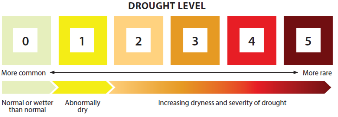
Provincial drought classification levels for the selected area.
🌧️ Precipitation level
Level 0 (84th Percentile)
πŸ’¦ Streamflow level
Level 1 (23th Percentile)
What this means
Drought Table Legend
Drought classification levels based on recent precipitation and streamflow percentiles.
Live Feed
  • Leqamel Deroche Creek β€” 2026-04-08 08:30
    ⚠️ Missing data for Leqamel Deroche Creek-Preliminary Discharge for 6690.540292866667 minutes. Latest record time: 2026-04-03 17:00:00
  • Leqamel Deroche Creek β€” 2026-04-07 20:30
    ⚠️ Missing data for Leqamel Deroche Creek-Preliminary Discharge for 1680.0 minutes. Latest record time: 2026-03-31 09:30:00
  • Leqamel Deroche Creek β€” 2026-04-01 09:30
    ⚠️ Missing data for Leqamel Deroche Creek-Preliminary Discharge for 1440.54269455 minutes. Latest record time: 2026-03-31 09:30:00
  • Leqamel Deroche Creek β€” 2026-03-24 10:00
    ⚠️ Missing data for Leqamel Deroche Creek-Preliminary Discharge for 5085.049651016667 minutes. Latest record time: 2026-03-20 21:15:00
  • Leqamel Deroche Creek β€” 2026-03-23 22:00
    ⚠️ Missing data for Leqamel Deroche Creek-Preliminary Discharge for 4365.049214133333 minutes. Latest record time: 2026-03-20 21:15:00
  • Leqamel Deroche Creek β€” 2026-03-23 10:00
    ⚠️ Missing data for Leqamel Deroche Creek-Preliminary Discharge for 3645.047597416667 minutes. Latest record time: 2026-03-20 21:15:00
  • Leqamel Deroche Creek β€” 2026-03-22 22:00
    ⚠️ Missing data for Leqamel Deroche Creek-Preliminary Discharge for 2925.0411861166667 minutes. Latest record time: 2026-03-20 21:15:00
  • Leqamel Deroche Creek β€” 2026-03-22 09:30
    ⚠️ Missing data for Leqamel Deroche Creek-Preliminary Discharge for 2175.5367399666666 minutes. Latest record time: 2026-03-20 21:15:00
  • Leqamel Deroche Creek β€” 2026-03-21 21:30
    ⚠️ Missing data for Leqamel Deroche Creek-Preliminary Discharge for 1455.5240870999999 minutes. Latest record time: 2026-03-20 21:15:00
  • Leqamel Deroche Creek β€” 2026-03-15 09:00
    ⚠️ Missing data for Leqamel Deroche Creek-Preliminary Discharge for 9615.038785733333 minutes. Latest record time: 2026-03-08 16:45:00
  • Leqamel Deroche Creek β€” 2026-03-14 20:30
    ⚠️ Missing data for Leqamel Deroche Creek-Preliminary Discharge for 8865.521922299999 minutes. Latest record time: 2026-03-08 16:45:00
  • Leqamel Deroche Creek β€” 2026-03-14 08:00
    ⚠️ Missing data for Leqamel Deroche Creek-Preliminary Discharge for 8115.050795749999 minutes. Latest record time: 2026-03-08 16:45:00
  • Leqamel Deroche Creek β€” 2026-03-13 20:00
    ⚠️ Missing data for Leqamel Deroche Creek-Preliminary Discharge for 7395.0424572 minutes. Latest record time: 2026-03-08 16:45:00
  • Leqamel Deroche Creek β€” 2026-03-13 07:30
    ⚠️ Missing data for Leqamel Deroche Creek-Preliminary Discharge for 6645.5328819999995 minutes. Latest record time: 2026-03-08 16:45:00
  • Leqamel Deroche Creek β€” 2026-03-12 19:30
    ⚠️ Missing data for Leqamel Deroche Creek-Preliminary Discharge for 5925.526992666667 minutes. Latest record time: 2026-03-08 16:45:00
  • Leqamel Deroche Creek β€” 2026-03-12 07:00
    ⚠️ Missing data for Leqamel Deroche Creek-Preliminary Discharge for 5175.045215183333 minutes. Latest record time: 2026-03-08 16:45:00
  • Leqamel Deroche Creek β€” 2026-03-11 19:00
    ⚠️ Missing data for Leqamel Deroche Creek-Preliminary Discharge for 4455.038878483333 minutes. Latest record time: 2026-03-08 16:45:00
  • Leqamel Deroche Creek β€” 2026-03-11 06:30
    ⚠️ Missing data for Leqamel Deroche Creek-Preliminary Discharge for 3705.5265206833333 minutes. Latest record time: 2026-03-08 16:45:00
  • Leqamel Deroche Creek β€” 2026-03-10 18:00
    ⚠️ Missing data for Leqamel Deroche Creek-Preliminary Discharge for 2955.053198683333 minutes. Latest record time: 2026-03-08 16:45:00
  • Leqamel Deroche Creek β€” 2026-03-10 05:30
    ⚠️ Missing data for Leqamel Deroche Creek-Preliminary Discharge for 2205.5409769333332 minutes. Latest record time: 2026-03-08 16:45:00
Live Feed
  • Leqamel Deroche Creek β€” 2026-04-08 08:30
    ⚠️ Missing data for Leqamel Deroche Creek-Preliminary Discharge for 6690.540292866667 minutes. Latest record time: 2026-04-03 17:00:00
  • Norrish Creek β€” 2026-04-08 03:00
    πŸ”₯ 7-day streamflow percentile changed from 0 to 1
  • Leqamel Deroche Creek β€” 2026-04-07 20:30
    ⚠️ Missing data for Leqamel Deroche Creek-Preliminary Discharge for 1680.0 minutes. Latest record time: 2026-03-31 09:30:00
  • Leqamel Deroche Creek β€” 2026-04-01 09:30
    ⚠️ Missing data for Leqamel Deroche Creek-Preliminary Discharge for 1440.54269455 minutes. Latest record time: 2026-03-31 09:30:00
  • Leqamel Deroche Creek β€” 2026-03-24 10:00
    ⚠️ Missing data for Leqamel Deroche Creek-Preliminary Discharge for 5085.049651016667 minutes. Latest record time: 2026-03-20 21:15:00
  • Leqamel Deroche Creek β€” 2026-03-23 22:00
    ⚠️ Missing data for Leqamel Deroche Creek-Preliminary Discharge for 4365.049214133333 minutes. Latest record time: 2026-03-20 21:15:00
  • Leqamel Deroche Creek β€” 2026-03-23 10:00
    ⚠️ Missing data for Leqamel Deroche Creek-Preliminary Discharge for 3645.047597416667 minutes. Latest record time: 2026-03-20 21:15:00
  • Leqamel Deroche Creek β€” 2026-03-22 22:00
    ⚠️ Missing data for Leqamel Deroche Creek-Preliminary Discharge for 2925.0411861166667 minutes. Latest record time: 2026-03-20 21:15:00
  • Leqamel Deroche Creek β€” 2026-03-22 09:30
    ⚠️ Missing data for Leqamel Deroche Creek-Preliminary Discharge for 2175.5367399666666 minutes. Latest record time: 2026-03-20 21:15:00
  • Leqamel Deroche Creek β€” 2026-03-21 21:30
    ⚠️ Missing data for Leqamel Deroche Creek-Preliminary Discharge for 1455.5240870999999 minutes. Latest record time: 2026-03-20 21:15:00
  • Leqamel Deroche Creek β€” 2026-03-15 09:00
    ⚠️ Missing data for Leqamel Deroche Creek-Preliminary Discharge for 9615.038785733333 minutes. Latest record time: 2026-03-08 16:45:00
  • Leqamel Deroche Creek β€” 2026-03-14 20:30
    ⚠️ Missing data for Leqamel Deroche Creek-Preliminary Discharge for 8865.521922299999 minutes. Latest record time: 2026-03-08 16:45:00
  • Leqamel Deroche Creek β€” 2026-03-14 08:00
    ⚠️ Missing data for Leqamel Deroche Creek-Preliminary Discharge for 8115.050795749999 minutes. Latest record time: 2026-03-08 16:45:00
  • Leqamel Deroche Creek β€” 2026-03-13 20:00
    ⚠️ Missing data for Leqamel Deroche Creek-Preliminary Discharge for 7395.0424572 minutes. Latest record time: 2026-03-08 16:45:00
  • Leqamel Deroche Creek β€” 2026-03-13 07:30
    ⚠️ Missing data for Leqamel Deroche Creek-Preliminary Discharge for 6645.5328819999995 minutes. Latest record time: 2026-03-08 16:45:00
  • Leqamel Deroche Creek β€” 2026-03-12 19:30
    ⚠️ Missing data for Leqamel Deroche Creek-Preliminary Discharge for 5925.526992666667 minutes. Latest record time: 2026-03-08 16:45:00
  • Leqamel Deroche Creek β€” 2026-03-12 07:00
    ⚠️ Missing data for Leqamel Deroche Creek-Preliminary Discharge for 5175.045215183333 minutes. Latest record time: 2026-03-08 16:45:00
  • Leqamel Deroche Creek β€” 2026-03-11 19:00
    ⚠️ Missing data for Leqamel Deroche Creek-Preliminary Discharge for 4455.038878483333 minutes. Latest record time: 2026-03-08 16:45:00
  • Leqamel Deroche Creek β€” 2026-03-11 06:30
    ⚠️ Missing data for Leqamel Deroche Creek-Preliminary Discharge for 3705.5265206833333 minutes. Latest record time: 2026-03-08 16:45:00
  • Leqamel Deroche Creek β€” 2026-03-10 18:00
    ⚠️ Missing data for Leqamel Deroche Creek-Preliminary Discharge for 2955.053198683333 minutes. Latest record time: 2026-03-08 16:45:00